I walked in this part of Kosciusko National Park in November 2023 with an NPA group led by Richard Thompson, and again in May and October 2025. However these notes are entirely my work and my responsibility. They are a supplement to the map, not a replacement. On all three trips we walked from Tooma Dam (actually from the start of the Dargals Trail) to Pretty Plain Hut to Wheeler's Hut to Tooma Dam. But several itineraries are possible so this page tries to cover the area in general rather than one specific walk. This is a first-hand account except where noted.
The main fire trails are the Dargals Trail, from near Tooma Dam to Paton's Hut and on south across the Tooma River then up into the forest; the Snakey Plain Trail, from the Cabramurra-Khancoban Road a few kilometres west of Tooma Dam to Wheeler's Hut; and the Hell Hole Trail, from the Dargals Trail just south of the Tooma River to the Jagungal area near Derschko's Hut. There is a new signpost on the Dargals Trail at the start of the Hell Hole Trail.
There is also a spur trail off the Dargals Trail a few kilometres south of Paton's Hut. There is a signpost but it is old and illegible. The spur trail soon breaks into two branches, one crossing the Tooma River and going up to Wheeler's Hut, the other (recently signposted) going to a gauging station at another point on the Tooma River.
All of these routes are open and easy to follow. There are a lot of ups and downs. Crossing the Tooma River requires care; at our two crossings, the water flowed at well above knee height in November 2023 and October 2025. It was very much easier in May 2025.
To walk out from Wheeler's Hut via the Snakey Plain Trail, follow the only trail (towards the Tooma River) for a few hundred metres, across two small creeks, then turn left (no signost) near the top of the next rise. I've only walked from Wheeler's Hut to Snakey Plain (where there is a new NPWS signpost) and back myself, but I'm told that the trail is quite clear all the way to the road, and that it has several steep parts that make it a harder option than crossing the Tooma River and walking out on the Dargals Trail. That agrees with what I saw.
Options for off-track walking are much more limited in this area than in the higher country around the Main Range or Jagungal. There are three vegetation types. First, there is open snowgrass in the frost hollow valleys, where visibility is good but the tussocks underfoot are tiring and sometimes boggy. Second, there is bossiaea scrub along the valley slopes, which is very tiring to walk through, indeed close to impenetrable when full grown. And third, there is forest surrounding the entire area higher up, where off-track walking is also likely to be very tiring owing to thick scrub (including bushfire regrowth) at ground level. So most off-track routes follow open snowgrass valleys.
Every map seems to show different tracks to Pretty Plain Hut. Much of what is shown is wrong and it would be a big mistake to trust whatever map you have. Here are the main options.
(1) From the Hell Hole Trail just west of where it crosses the Tooma River (at the top of the first slope), head south, first up the Tooma River, then up Bulls Head Creek to Pretty Plain Hut. This is the usual way to get to Pretty Plain Hut. It's open snowgrass all the way, except just at first. There is a faint track up the western edge of the valley floor, except that in one place, a wide open area about halfway up, where the Tooma River emerges from the forest, the route cuts straight across (south), mostly with no track, to where the valley narrows again. Do not cross either the Tooma River or Bulls Head Creek at any point.
(2) From Pretty Plain Hut, head north-west at first, then south up the forested ridge separating Bulls Head Creek from Pretty Plain Creek, then take a sharp right turn down into the open valley of Pretty Plain Creek, then south up the eastern side of the valley of Pretty Plain Creek, following open snowgrass all the way to the Strumbo Trail, which runs east-west across the gap at the head of the valley. (Let's call everything so far the Pretty Plain Hut Trail.) Then turn right and head up the Strumbo Trail to the junction with the Dargals Trail. In November 2023 this was not an obvious route, but in May 2025 it had all been mechanically cleared and was a working fire trail. The Strumbo Trail was clear in both directions from the Pretty Plain Hut Trail junction, although the east-going part was only half as wide as the west-going part, and I have heard that it is no longer a through route (I did not go that way). The west-going part was in excellent condition, making this whole route (Pretty Plain Hut Trail, Strumbo Trail western part, and Dargals Trail) easier underfoot than (1) for reaching Pretty Plain Hut from the north, although longer and higher.
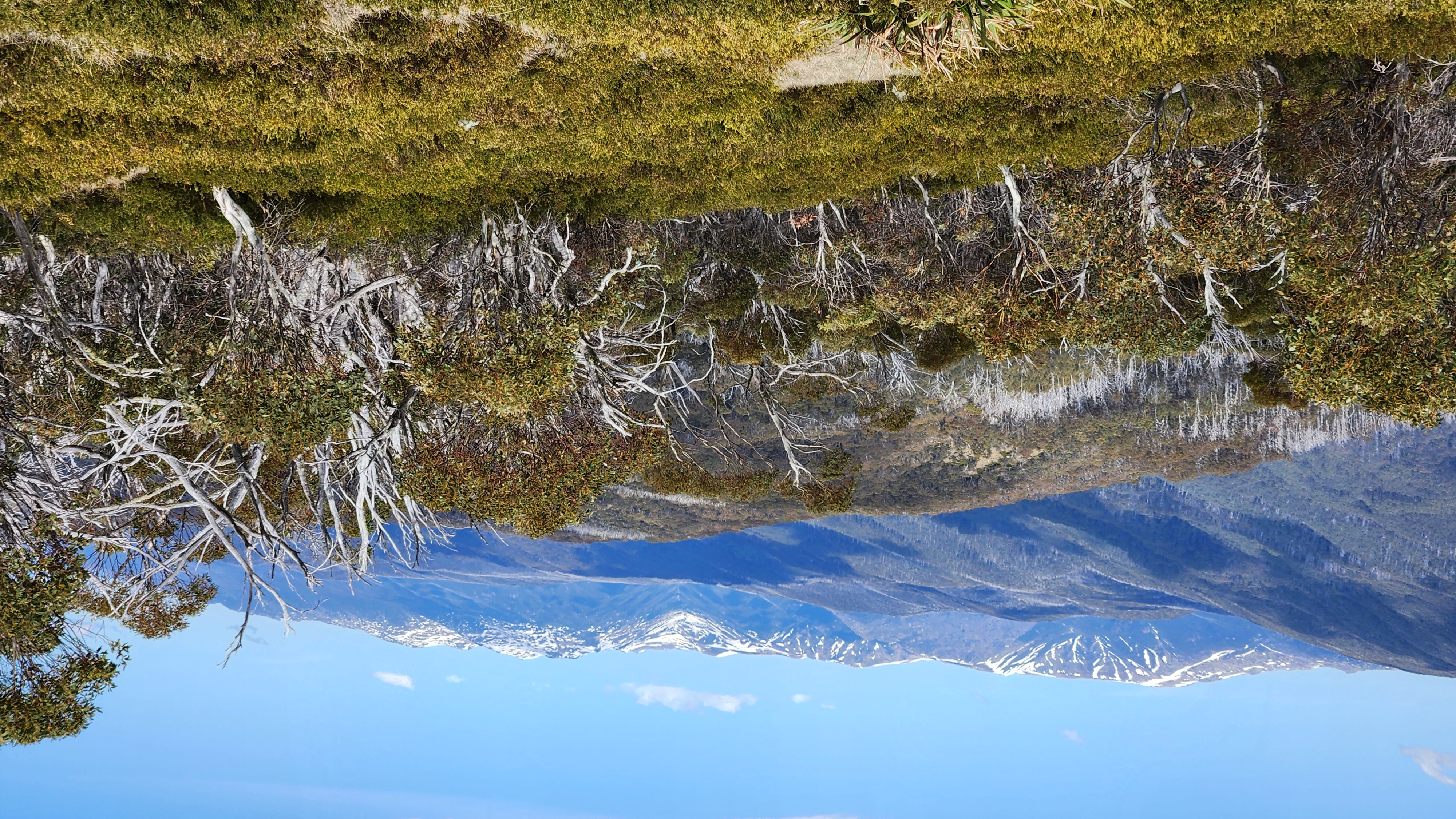
In October 2025 we followed this route right through, starting the day's walk where the Dargals Trail crosses the Tooma River, and following the Dargals Trail, Strumbo Trail, and Pretty Plain Hut Trail to Pretty Plain Hut. It's a long day with several big climbs and no water until near the end, so it would probably be a bad idea to start from further back (from Paton's Hut, say, or Wheeler's Hut). But it's a great walk, with miles of unburnt forest, and great views right from the trail: to the west shortly before reaching the Everard's Flat Trail junction, and towards the Main Range shortly before reaching the Strumbo Trail junction (see photo by Frank Hufschmid, October 2025).
There are new NPWS signposts at the Dargals/Everard's Flat Trail junction, and an elaborate but broken-down and illegible signpost at the Dargals/Strumbo junction. There is no signpost at the Strumbo/Pretty Plain Hut Trail junction, but the junction is obvious and is also marked out by the fact that the Strumbo Trail reaches a low point there then starts to climb for the first time since the Strumbo/Dargals junction. Both the Everard's Flat Trail and the Dargals Trail south of the Strumbo junction appear to be open (I did not go those ways).
(3) From Pretty Plain Hut, follow (2) into the valley of Pretty Plain Creek, but after heading south for a short distance, turn west across the creek and up through the forest to the Dargals Trail. This route is shown on one map as a fire trail. We saw no sign of any track branching off (2) in 2025. This route would lead you into thick scrub at first and thick forest after that. Even if it saved you time compared with (2), you would miss the views.
(4) From Pretty Plain Hut, head south, first up Bulls Head Creek, then through forest, emerging onto the Strumbo Trail. There is no trail, not even a foot track, up Bulls Head Creek south of Pretty Plain Hut. We explored this route in November 2023 for about one kilometre and it was open but very tiring. I do not know whether the Strumbo Trail is clear at the point where this trackless route would reach it.
(5) Directly across country from Grey Mare Hut to Pretty Plain Hut. This unlikely route is apparently sometimes taken by parties in search of self-punishment. Accounts in the Pretty Plain Hut log book, and one first-hand account given to me, speak of miles of thick scrub. Cutting across from Grey Mare Hut to the Strumbo Trail, then linking up with (2), might be less painful; I don't know. I saw this country from the Dargals Trail and it looked challenging.
The best camp sites are Pretty Plain Hut and Wheeler's Hut. Each has spots for at least six tents, plus a pit toilet. Other camp sites are at the point where the Dargals Trail crosses the Tooma River (we camped on the south side of the crossing), the gauging station, the point where the Hell Hole Trail crosses the Tooma River, and a point halfway from the Hell Hole Trail to Pretty Plain Hut, at the north end of the large open area, beside the Tooma River.
Virtually any creek shown on your map will have good water. At Wheeler's Hut there is a foot track running north along the hillside to water, first a trickle with old planks across it, and then (after pushing through some bossiaea) down to a much better creek. I've been told that this track continues to the Snakey Plain Trail, but I suspect that if it ever did it is now lost in scrub.
If you are walking from Pretty Plain Hut or the Hell Hole Trail to Wheeler's Hut, you will probably be tempted to cut across country from the Dargals Trail/Hell Hole Trail junction directly to Wheeler's Hut. It is about 2.5 kilometres in a straight line and avoids two crossings of the Tooma River that you have to make in order to get to Wheeler's Hut on tracks. I suppose that on balance it is worth doing, but it's scrubby and you might get lost. Anyway I've walked this dubious short cut three times, so here is my guide to it.
Starting from the junction of the Dargals Trail with the Hell Hole Trail, walk south along a flat section of the Dargals Trail for a hundred metres or so until a clear snowgrass gap appears to your right. Walk west over this gap and down the gulley on the other side of it to Broadway Creek. There is a foot track down this gulley, but it is hard to follow and there is a lot of scrub to push through, even on the track.
At the bottom of the gulley, turn right and walk north down Broadway Creek for fifty metres or so, then cross it. The valley is open but the tussocks and bogs make it hard going. Then head west up onto the very scrubby ridge (thick bossiaea) that separates Broadway Creek from Dargals Creek. There is one obvious place to head up, but it soon degenerates into scrub, and sadly there seems to be nothing better, at least on the eastern side of the ridge. There are patches of open ground in the shallow gulleys and gaps, and there are two patches going down the western side of the ridge, one on the direct line, the other some way further north. But none of these patches goes right through from Broadway Creek to Dargals Creek, I believe, making some difficult bossiaea unavoidable.
Anyway, assuming now that you are on an open gap on the ridge, you just need to walk west to be rewarded with a clear view of Wheeler's Hut. Down the slope you go, across Dargals Creek with its old alluvial gold workings, and up the other side.
Going the other way, from Wheeler's Hut, head for the clear patch on the direct line going up onto the ridge separating Dargals Creek and Broadway Creek. Go up it, then angle down the other side into Broadway Creek, turn right up the creek, then turn left up the gulley (if you can find it).